
Before this article on Peru starts, a little spoiler alert: At the end of this article... maybe somewhere in between, there is a hidden clue as to when Tatjana and Artur plan to put their feet back on German soil and return to their flat in Düsseldorf 😉
Peru
After our extensive time in Iquitos and the Amazon rainforest, we travelled to Lima.
Lima
Lima is the capital of Peru and by far the largest city in the country. More than 10,000,000 inhabitants live here. We had great respect for the city because it has the reputation of being the most dangerous city in South America. As we have experienced a few differences in altitude here in Peru, we will add the altitudes at which we are travelling. Here is the altitude of Lima: 161 metres above sea level ☺️
We were particularly surprised that Lima is practically in the desert. We had a completely different idea. There are high sand dunes and mountains all around and there are only many plants and trees in the city centre. Outside the city centre there are only plantations and trees where there is a river or an underground water source.
Even though some Peruvians told us that the Miraflores neighbourhood doesn't represent Lima, we stayed in this part of the city for one night for safety reasons. As we don't like big cities that much anyway, this was enough for a first impression.
After our short stopover in Lima, we travelled on into the desert to the world-famous Nazca Lines, where the bus broke down and it felt like 40°C outside.
Nasca
Nazca or Nazca (old spelling) is 520 metres above sea level. There are ancient aqueducts here, which we visited, where water still flows today in the middle of the desert. The ancient Nazca culture understood and discovered the existence of underground rivers and opened them up with fascinating structures, making the water usable for all inhabitants. This made it possible to farm and settle in the desert. In addition to the world-famous Nazca Lines, there are also various other, smaller lines and shapes in the region, some of which we looked at. Similar to hieroglyphics, the lines and ground drawings are called "geoglyphs". Here are a few pictures.
The Nazca Lines are one of the greatest mysteries in the world and are between 1400 and 2800 years old. Some of the lines are over two-digit kilometres long and are drawn like a line with a ruler in the Nazca Desert. The lines show, for example, the routes to certain cities in Latin America to the exact metre or indicate certain celestial events, such as where the sun is at the summer solstice or winter solstice. On the other hand, there are hundreds of different special figures that have been moulded precisely and symmetrically into the stone desert. It can be assumed that they were created between 200 BC and 500 AD. Some of the drawings are several kilometres long and up to 1.1 km wide. They include an astronaut, a lizard, spiders and a hummingbird. The barren, sandy and rocky landscape with hills and the fact that it never rains here are the reason why the drawings are still preserved today. The creators removed layers of dark stones to reveal lighter-coloured sand. The difference in colour can still be seen today. It is also astonishing that footprints were only found on very few lines. The rest of the lines were not walked on!
The prevailing opinion among scientists is that the people of the Nazca culture created these lines/drawings, but no one has any proof of what they mean. But there are of course some really interesting theories. The German scientist Maria Reiche has spent most of her life researching the lines. She has come to the conclusion that the Nazca Lines represent a gigantic astronomical calendar. Today they are a UNESCO cultural heritage site and a museum has been built next to her grave in honour of Maria Reiche, which we also visited. There we saw some artefacts (documents, drawings, a replica of her living and working room with original objects, her VW bus, lots of ceramics and even a rather creepy-looking mummy) that was "found" in the desert in the cemetery.
Ein Schweizer Autor (Erich von Däniken) wiederum hat die Theorie aufgebracht, dass die Linien eine riesiges Landebahnsystem für Ufos von Aliens darstellen.
The lines are best seen from the air, but we didn't want to fly over them.
There is an observation tower on the Pan-American Highway, which was built through the middle of the desert and unfortunately also through the lines. From here we could see three of the figures: the lizard, the hands and the tree, and we could see them very well 😊.
After the lines, we continued our journey. This time with the aim of travelling deep into the Andes. At around 9000 kilometres in length, the Andes are the longest mountain range in the world that lies over water and almost completely crosses South America from north to south. At the same time, with 42 mountains over 6000 metres high, the Andes are the highest mountain range outside Asia and with these considerable heights they can significantly influence the climate between the Atlantic side and the Pacific side of the continent.
Arequipa
We spent 2 nights in Arequipa to acclimatise to the altitude. Arequipa is 2335 metres above sea level... That wasn't a big problem for us. We were able to carry on almost as normal as before. The only thing that got us out of breath more quickly was climbing the stairs and walking at a brisk pace. Among other things, we attended a cocoa workshop here, where we learnt how cocoa beans are extracted from cocoa pods, how they are processed into cocoa paste and then made our own chocolates. By the way, during the subsequent tasting of various chocolates, we were able to taste in direct comparison how fake industrial chocolate can taste, sometimes containing less than 2% cocoa mass and certainly no cocoa butter. The main ingredients are usually sugar and palm oil. We have already written a lot about palm oil in the Malaysia article. There is more interesting information on cocoa below. You can look forward to it 😉
After coping well with the altitude, we headed higher... higher and higher... towards the Colca Canyon. With the bus at 3500m, we first had a break and a coca tea, as well as coca sweets and coca leaves to chew against altitude sickness. All Colombians, Peruvians and, as far as we know, Bolivians who live in the Andes chew coca leaves to a) either get fitter, as the active ingredient in the leaves has a stimulating effect, or b) to work against altitude sickness, as some of the locals themselves travel back and forth between 1000m and 4000m above sea level and also work there.
Did you know that the water for making tea/coffee/food starts to boil earlier due to the low air pressure? It doesn't reach 100°C, but starts to boil at lower temperatures.
This means that pasta takes 15 minutes instead of 8 minutes, for example; potatoes take almost 60 minutes, depending on how many there are, and the boiled water from the kettle is not completely free of bacteria! Therefore, if you have a sensitive stomach, you may catch a few problems here. As a rule of thumb, it is said that the water reaches its boiling point 1°C earlier for every 300 metres of altitude. This means that tea at 3500 metres above sea level has already boiled at around 88 degrees Celsius instead of 100°C. And to complete the physics lesson: in a pressure cooker, in which the pressure is artificially increased, the water can only start to boil at around 120 degrees Celsius, which is why the things in it are ready more quickly 😉
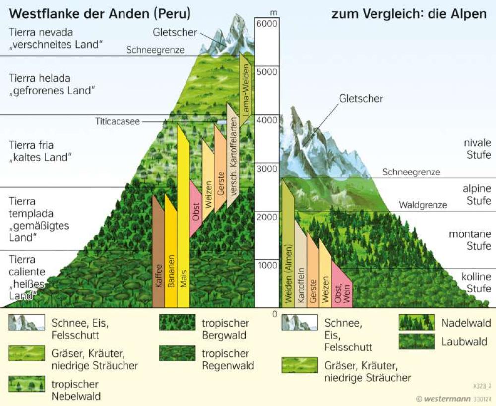
Have you also heard of the tree or forest line? Because on many of the pictures in this section of the journey there are simply no trees to be seen, only bushes, shrubs or even just grasses. Here is a brief explanation based on a diagram from Diercke:
All plants need certain climatic conditions to grow. This means that all 4 elements must be present. Fire, in the form of sun, earth, water and air. The tree line is the height above which no more trees grow. The tree line is the height above which the trees no longer touch each other, i.e. no longer form a "forest". These limits are different all over the world, as there are different trees everywhere and/or the trees have adapted to the climatic conditions. The diagram clearly shows this in the case of wheat and fruit, for example. Yes, they are not trees, but this also applies to other plant species, although they are called differently. Here, wheat and fruit can be found up to a maximum of around 1500 metres above sea level. In the Andes, the Incas managed to adapt the plants to the conditions at high altitude with special projects and a lot of patience, and in the Andes, for example, wheat and fruit can be found between around 1500 and 2500 metres above sea level.
Keep your eyes open on your next visit to the mountains, sometimes you can see the border very clearly because it runs across the mountain as if drawn with a ruler.
As the whole topic is of course not so simple and there is the climatic forest line, the edaphic forest line, the alpine and polar forest line, and many more, here is the link to Wikipedia for more detailed information if you are interested in the topic. There is also a list with explanations of the limits worldwide ☺️

(Retrieved: 26/11/2023 - 21:51 (La Paz))
After fortifying ourselves and stocking up on various anti-altitude sickness remedies, we continued up a pass to its highest point, which can be reached by bus between Arequipa and Cusco: 4910 metres above sea level. Just for orientation, the highest mountain in Germany is the Zugspitze at 2962m above sea level and the highest mountain in the Alps in Europe is Mont Blanc at 4805m. An anecdote on the subject of how Peruvians feel in Europe will come later. Let's put it this way, we didn't feel so comfortable at this altitude in the 15 minutes we were there and bought some great homemade Alpacca jumpers. The 100m + 15 steps to the toilet alone were as exhausting as walking up 10 flights of stairs in Düsseldorf, loaded down with shopping bags! A fascinating experience for us!
Colca Canyon
Once we arrived in the town of Chivay in the Colca Canyon, "only" around 3635 metres above sea level, we visited fantastic thermal springs, a folklore event in which we were introduced to Peruvian Andean culture and where Tatjana and Artur were the only non-South American tourists to be persuaded to take part involuntarily 🙈 and a unique viewpoint for the Andean condor. A majestic bird with a wingspan of 2-3 metres, which uses the thermals on the mountains to drift up to high altitudes in the morning without flapping its wings. But see for yourself... and it always has the third deepest canyon in the world below it.
Oh yes, we almost forgot. Have you ever heard of the terraces of the Incas?
- No? Perfect! More information on this later ☺️
- Yes, great! Did you know that these were built all over the Andes region, where the Incas, or in some cases the ancestors of the Incas, lived? Including in the Colca Canyon? We found that very fascinating.
Puno and Lake Titicaca
What are Artur and Tatjana doing for 3 nights at 3829 metres above sea level? Exactly! They sleep in a hotel in Puno, at 3819 metres above sea level, on the world-famous Lake Titicaca. Why world-famous, you ask? Because Lake Titicaca is the highest commercially navigable lake in the world. Yes, there are higher lakes, but these cannot or are not navigated by large ships. As a rough guide: Lake Titicaca is 15 times larger than Lake Constance.
At the western corner of Lake Titicaca are the floating reed islands of the Uros (a South American tribe). We visited them on a half-day tour from Puno. The water in front of the city is completely polluted and unfortunately stinks terribly. There is no infrastructure for sewage treatment, so everything is channelled into the lake. This and other pollution caused by heavy fish farming and the many mines around the area means that the lake is in danger of tipping over. You can find more information here: GNF – Bedrohter See des Jahres 2023: Titicacasee (globalnature.org)
The people of Puno and the Uros are very concerned about this, as tourism is a major source of income.
When we arrived on our boat at the floating islands, the odour had fortunately disappeared and the water was fresh again. What we were able to experience was the really exciting culture of the Uros on their now 100 floating islands. Hundreds of years ago, the tribe wanted to isolate themselves from rival peoples (including the Incas) in order to protect themselves. They came up with the idea of building the floating islands out of reeds. The reeds they used for the construction grew on the lake and consisted of a firm root system and robust stems. The islands are based on a thick layer of roots, which are connected to each other and anchored to the lake bed with sticks and ropes. The stalks are laid on top of this, which have to be replaced regularly (approx. every fortnight) because the lower layers naturally rot. The Uros use this material to make their houses, canoes and souvenirs as well as their islands.
You're probably wondering how amazing it is that we can cope with the altitude so well... erm... to be honest, despite the coca tea and leaves and also despite the Sorojchi pills, it almost knocked Artur out and made Tatjana really struggle. Tatjana was out of breath very quickly and we had to go very slowly. Artur didn't have too many problems during the day, but he didn't sleep for several nights. During the day, his head made sure that he breathed more and faster, which was fine. At night, however, when transitioning from conscious control to "I let the body do its own thing", he panicked about suffocating and was awake again. After 2 days without a minute's sleep, we had to pull the ripcord and admit to ourselves that we flatlanders had overdone it. Consequence: We have to go down!!! Somewhere around 1500 - 2500 metres. The range that is considered "okay".
Short insert: We already pay a lot of attention to all factors. Both our safety from the outside (surroundings, people, food) and from the inside (how we feel and how each of us assesses a situation). As soon as one of us realises that the other doesn't look OK but doesn't want to admit it, we pull the ripcord. Or even if one of us says that something is wrong here, he/she has a bad feeling or feels uncomfortable. We won't jeopardise our lives with some stupid action. So don't worry. We'll take good care of each other and, if worst comes to worst, we'll plan our trip around ☺️ There's a lot to discover below 3000 metres ☺️
Back to the subject matter:
After Puno and 2 nights in Cusco (3416m above sea level), which we had to break off prematurely, and 2 more nights in Urubamba (2870m) in the Sacred Valley, we went to Ivochote (<1000m). Never heard of it? Neither had we 🙈 But what awaited us there was endless hospitality, super exciting and instructive topics that we were allowed to look into and a story that really moved us.
Ivochote – Perú Puro
To get to Ivochote, we had to drive from Urubamba (1h drive from Cusco) to Quillabamba (approx. 6h drive) and from there another 6h drive with the higher minibus to Ivochote. On the way we crossed a 4316m high pass with hairpin bends and slopes... we were glad not to be travelling along this road in a bus, but in a small car that didn't use the whole road.
We regularly deal with sustainability issues on our journey and it is important to us to put good examples in the spotlight. Because this encourages and shows inspiring solutions.
We were therefore delighted to be able to gain an insight into the work of PERÚ PURO and "Frederic - Help for Peru" on site in Ivochote. We would like to take this opportunity to thank Tina Teucher and Dr Frauke Fischer once again. Together with Dr Arno Wielgoss, Frauke is the managing director of the organic fine chocolate manufacturer PERÚ PURO. As is so often the case in life, the origin of this wonderful company is a sad story.
"In the summer of 2000, Frederic Wielgoss, aged 20, was caught in a whirlpool while swimming in the Urubamba jungle river and has been missing ever since. Frederic's friends initiated an appeal for donations to support the family with the costs of the costly search operation. When the search was unsuccessful, the Wielgoss family decided to use the surplus money donated to help people in the region. This is how the non-profit organisation "Frederic - Help for Peru" was founded at the end of 2000" (Source: Unser Ursprung – Frederic – Hilfe für Peru (frederic-hfp.de)).
The organisation supports the local smallholders in many ways to lead a dignified, self-determined life. The main problems in the region are discrimination against women and indigenous minorities, deficiencies in hygiene standards and medical care and an unbalanced diet. In addition, slash-and-burn agriculture and monocultures pose significant threats to the region's tropical rainforest. Furthermore, fluctuating world market prices and a lack of sales opportunities prevent sustainable and regenerative agriculture. (Source: Frederic – Hilfe für Peru (frederic-hfp.de))
This is where the "Frederic - Hilfe für Peru" association and the company PERÙ PURO come in. They enable the cultivation of the organic fine flavoured cocoa Chuncho for dream chocolates. This is the best cocoa in the world, and we tell you, you can taste it.
We learnt a lot on site and were amazed. Unlike conventional farms, PERÚ PURO preserves the rainforest. We were able to see this for ourselves on site. We spent a whole week with the head of the local small farmers' cooperative APECMU Jonathan and his family as well as with his colleague Demnis and his family. A German volunteer, Leo Ruppert, was also there to help us overcome language barriers where necessary. Many thanks again to you, Leo, for your help. We were able to gain an insight into the cultivation techniques, visit the preserved primary rainforest on the two fincas, learn what needs to be taken into account when reforesting trees, taste incredibly delicious Chuncho cocoa and the super tasty pulp of the cocoa fruit. We also made our own drinking chocolate (block chocolate) from 100% cocoa. We even spent the last night at Jonathan's finca 😊.
The cultivation systems and the preserved primary rainforest protect an incredible biodiversity that we humans need for our livelihoods. The cultivated areas themselves consist of agroforestry systems, which replicate the rainforest's principle of stacks and in which native trees and shrubs are planted. This proactively ensures nutrient-rich soil and a species-rich habitat. We were also able to provide a little support in setting up a new tree nursery. But take a look for yourself. Pictures speak more than 1000 words. (Sorry, there are a few more pictures, we experienced a lot!)
We also went on a short excursion to the nearby Pongo de Mainique National Park. It was breathtaking and very exciting to get there and back via the Urubamba River.
PERÚ PURO has also made her heart shine when it comes to Tatyana's favourite topic of human rights. After all, at its core, it is about nothing other than protecting and enabling a dignified and self-determined life.
- The company's supply chain is completely transparent and traceable. There are no middlemen, but instead long-term business partnerships that are characterised by the joint development of all processes and projects.
- The smallholder families can be almost completely self-sufficient from their own farm. This is because, in addition to cocoa, there is still space and time for their own garden with essential foodstuffs. In addition, the yields from cocoa are even higher in the long term than those from intensively managed monocultures.
- What can be done in Peru is done here. By creating value locally, jobs are created and training and global education are provided.
- PERÚ PURO negotiates cocoa prices with its business partners on an equal footing and pays twice the organic fair trade price, so that small farmers can lead a secure and self-determined life.
If this appeals to you now and you still need a great Christmas present, take a look here: PERÚ PURO – Edelkakao, Gourmetschokolade und Hochlandkaffee – Regenwaldschutz durch Genuss (perupuro.de)
We can also recommend the podcast "tierisch!" by Frauke Fischer. This is available wherever there are podcasts. Tierisch – Weltwach
On the way back from Ivochote we went to Machu Picchu. There are two ways to get there. Either by train or on foot. We opted for the latter and walked for three hours along the railway line from Hydroelectrica to Aquas Caliente (Machu Picchu town).
Machu Picchu (2430 m above sea level)
In 1911, Yale professor Hiram Bingham claimed to have "discovered" Machu Picchu, the lost Inca city. He was led there by a local guide named Melchor Artega, because the local population knew the place and some even used the Inca terraces to plant their vegetables. So although Machu Picchu is always described as the lost city, it apparently never was. It is also assumed that Westerners were already in Machu Picchu before Bingham. But there is even a complete edition of the National Geographics from 1913, which only deals with Brimingham's "discovery". So if you want to delve deeper... 😉
There has also long been disagreement about what Machu Picchu actually was. Today, most archaeologists agree that it was a kind of holiday retreat for the noble Incas.
In order to take the best pictures, we booked our tickets for Machu Picchu early on. On the recommendation of Arno Circuit 4 + Waynapicchu ascent.
We were there: 5:50 in front of the entrance gate. Super excited. The first group to enter this path that day. The entrance was at 6:00. It was magical. The sun had just risen about 40 minutes ago and had not yet managed to dispel the clouds and haze. We took a close look at everything with our tour guide. Every stone sits perfectly on top of the other. The statics of the buildings and the rest of the structures are amazing. Careful attention was paid to how the stones were layered, at what angle, in which stone formation the stones interlocked and thus provided more stability, or special stones were made with holes at a 90 degree angle to strengthen the stability (as Machu Picchu is also located on the Ring of Fire and therefore in the earthquake zone) and to allow water to run underground. A feat that scientists still can't agree on how the Incas managed it.
Above, we promised to tell you more about the terraces (see also the article: Off into the jungle). In the mountainous regions where the Incas and their ancestors lived and their descendants still live today, there are many problems with growing food on the steep slopes. When it rains heavily, the good humus layer is washed away and stones and clay are left behind. The humus layer is blown away by the wind. Harvesting involves working on dangerous slopes where it is easy to slip and injure yourself. Huge terraces were therefore built with great vigour, consisting of a water-impermeable lower layer, which feeds the remaining water to the next terrace via a defined gradient. This is done through several layers of stone so that the water is filtered and not so much humus is needed; the top layer is the humus layer. Food is then grown on this layer. We both thought it was a very clever principle.
On the way back from Machu Picchu, we decided to acclimatise to the altitude slowly... even more slowly than the first time. Destination: Bolivia. The problem: Bolivia is located in the Andes and is therefore sometimes well above 3000 metres above sea level. So if it fails again and we can't cope with the altitude, we'll have to go back to the Pacific and continue in Chile. If it works, we'll continue via Bolivia ☺️
Sacred Valley
So we first spent a few days in the Sacred Valley. But why is it actually called the Sacred Valley? Machu Picchu has the shape of a condor. This symbolises the upper world/the sky. Cusco, the former capital of the Incas, centrally located between all the Inca sites, was built in the shape of a puma. The symbol for the world of the living. Only one Inca symbol is missing. A snake, because it represents the world of the dead. You can now believe in a coincidence or not. Cusco and Machu Picchu are connected by a river, the Urubamba, which meanders through the valley... the snake. This is why the valley is called the Sacred Valley. Along the entire route from Cusco to Machu Picchu, there are ancient Inca sites to the left and right of the river, a few kilometres away or sometimes right next to it. For example, we visited the Salineras, the salt mining areas of the Incas and today's Peruvians, which are still in use today. We also visited Moray, which was supposedly an experimental and breeding ground for the Incas to adapt seeds from other climate zones to the climatic conditions of the Andes. To be honest, it was a bit like a UFO landing site for us... We'll probably never know. If you would like to find out more about this topic, the buzzword here is "pre-astronautics".
We also used our time in the Sacred Valley to tidy up our inner selves and to delve deeper into various topics. We attended various courses and workshops here on meditation, breathwork, yoga, dealing with our inner child and tried to eat healthily the whole time. Of course, we also learnt about current and ancient Peruvian traditions. For example with our 7 chakras and healing stones and we have to say, even if it was quite a hocus pocus for Artur at the beginning, in the end he and Tatjana would like to delve deeper into the subject ☺️ Meditation can be very relaxing and the inner child is so built in from the ego that it consciously frees and focusses benötigt☺️. Tatjana is still hoping that Artur will become a dancer and singer 😁... Let's see if that works out 😋
We made new friends here. For example, John and Wayra, who introduced us to Peruvian traditions. Kevin, who lives in Peru in the Sacred Valley and was able to tell us a lot about the traditions and suggested the Sacred Valley as a travel destination, as well as Stephan and Rinita from the USA, who took part in some of the workshops with us and with whom we had a lot of fun. We will definitely stay in touch with you all and hope to see you again soon 🙏☺️
Anecdote about John: During a visit to Europe, he felt as if he could fly. He had so much oxygen in his body that jogging was really fun. He had the feeling that he could run endlessly.
Last but not least, we spent a few days in Cusco. Here are a few impressions of Cusco.
And if you're wondering whether we've managed to acclimatise to the altitude: Yes 😁 and we are currently writing this article on our way by bus to La Paz, the capital of Bolivia. So look forward to the next exciting post from Bolivia ☺️
Als ich das erste mal in Tibet die 3000 m überschritten habe, war mir genau so schlecht wie bei Artur, drei Tagen und drei Nächste fühlte ich mich elend. Dann habe ich mit “Experte” gesprochen und sie haben mich das Medikament DIAMOX (ein Diuretika) empfohlen. Als ich in Peru war, habe ich bei ersten Kopfschmerz genommen und war mich sofort wieder besser. Das gleiche habe ich auf dem Kilimandscharo erlebt. Dann meine Empfehlung um eine nicht nötige Krankheit zu vermeiden : über die 3000 eine Tablette Diamox nehmen. Liebe Grüsse Maria Luisa
Liebe Maria Luisa,
danke für deine sehr wertvolle Empfehlung!
Liebe Grüße
Tatjana